
Residential Community Design Supported by Topographic Survey Mapping
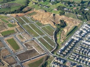
A topographic survey shows a developer the shape of the land before a new neighborhood gets designed on it. Streets, lots, drainage areas and open space all depend on how the ground rises and falls. Designing a community without that elevation data is like drawing a floor plan without knowing the walls. Measured terrain gives the whole plan a foundation it can rely on.
Mapping the Land Before the Neighborhood Takes Shape
Community design starts with understanding the ground it will sit on. A topographic survey measures elevations across the entire tract, capturing the slopes, high points and low areas that will shape the layout. Designers work from that map to place streets, lots and drainage where the land supports them.
Skipping this step invites expensive redesigns. A street routed across a steep grade or a lot placed in a natural low spot causes problems that surface during construction. Mapping the terrain first lets designers arrange the neighborhood to fit the land rather than fight against it.
Grade Differences Across Future Homesites
Individual lots rarely sit at the same height, and those differences matter. One homesite might slope toward the street while the one next door drops off toward a back corner. Topographic data reveals these grade changes across every future lot, which affects how homes, driveways and yards can be placed.
Designers use that information to plan lots that actually work. A lot with a steep drop may need a walkout design or a retaining wall, while a gentle slope allows more flexibility. Knowing each lot’s grade ahead of time keeps the community’s home designs realistic instead of forcing awkward fixes later.
Designing Around What the Land Already Has
Every tract comes with natural features, and good community design works them into the plan. Slopes, drainage paths, tree stands and other site conditions all influence where open space and homes should go. Topographic mapping shows where these features sit and how they connect.
Several natural elements tend to shape a layout:
- Existing slopes that suit trails, parks or buffers
- Drainage routes that guide where water should flow
- Tree stands worth preserving as green space
- Low areas better used for open space than homesites
Designing with these features instead of erasing them often produces a better neighborhood and lowers the cost of reshaping the land.
Fewer Earthwork Surprises at Budget Time
Earthwork is one of the biggest and least predictable costs in developing a community. Moving dirt, cutting slopes and filling low areas add up fast, and a surprise can wreck a budget. Topographic data helps a team estimate this work before the numbers get locked in.
With accurate elevations in hand, designers can plan grading that balances cut and fill and avoids unnecessary earthmoving. That foresight keeps costs closer to the estimate once construction starts. A neighborhood designed around the existing terrain simply needs less reshaping than one drawn without it.
Better Inputs for Roads and Utilities
The infrastructure behind a community depends heavily on elevation. Roads need proper grades, stormwater has to flow downhill and utilities follow the contours of the land. Engineers rely on topographic data to design all of it correctly.
Feed that data into infrastructure design and the systems work together. Streets drain the way they should, stormwater reaches the right outfalls and utility lines follow sensible routes. Accurate ground information is what lets a neighborhood’s roads and utilities function smoothly once residents move in.
Frequently Asked Questions
Why does a residential community need topographic mapping?
It provides the elevation data that streets, lots, drainage and grading all depend on. Designing a neighborhood without it risks layouts that do not fit the land.
How does terrain data affect the way lots are laid out?
Slope and elevation differences decide where homes, driveways and yards can go. The data helps designers arrange lots so each one works with its natural grade.
Can topographic mapping help control development costs?
Yes. By showing the terrain in advance, it lets a team plan grading that balances cut and fill, which keeps earthwork closer to the estimate.
Which natural features show up in the survey?
Slopes, drainage paths, low areas and the general shape of the land all appear. Designers use these to place open space and homesites sensibly.
When in the process should the mapping happen?
Before the layout is designed and before grading and infrastructure plans begin. Early mapping keeps every later decision grounded in the real terrain.
For a free land surveying quote, call us at (859) 577-9503 or send us a message by going here.
Posted in Topographic Survey