
Flood Exposure Review Using Certified Elevation Certificate Details
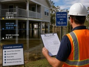
An elevation certificate is a document that records exactly how high a building sits compared to known flood levels. For anyone worried about flooding, those measured numbers replace vague fears with hard facts. The certificate spells out the height of the lowest floor, the ground around the structure and other reference points a surveyor records on site. Reading it correctly tells an owner where their building really stands in relation to flood risk.
What the Numbers on the Certificate Mean
The certificate is full of measurements, and each one has a purpose. The most important is usually the lowest floor elevation, which shows how high the living space or lowest enclosed area sits. Other figures cover the ground next to the building and features like vents or attached garages.
These numbers only make sense next to the flood level for the area. A surveyor measures the building precisely, then those heights get compared to the base flood elevation for that location. The gap between the two, whether the floor sits above or below that level, is what shapes flood risk and insurance discussions.
Measuring the Building Against Flood Rules
Flood requirements set a target height that structures are expected to meet. The elevation certificate shows whether a building clears that target or falls short. That comparison drives a lot of downstream decisions, from insurance pricing to what a lender will accept.
Owners often learn something surprising here. A home that seems safely dry might sit lower than the required level, or a building that looks vulnerable might actually rise well above it. Measured data settles the question instead of leaving it to appearances, which is exactly what insurers and reviewers want to see.
Remodels That Send You Back to the Document
Changes to a building can affect its elevation status, so certain projects call for a fresh look at the certificate. Anything that alters the structure’s height, footprint or lowest floor may need updated documentation.
Work that often triggers a review includes:
- Additions that expand the building’s footprint
- Major repairs that change the lowest floor
- Raising or lowering a structure
- Substantial remodels that reset the building’s value
Skipping the update on these projects can leave an owner with paperwork that no longer matches their home. That mismatch tends to surface at the worst time, during a claim or a sale.
Sharper Flood Questions for Home Shoppers
Buyers often ask only general questions about flooding, like whether a house has ever taken on water. An elevation certificate lets them ask better ones. Instead of relying on a seller’s memory, they can look at measured heights and see how the building compares to flood levels.
That shift changes the conversation. A buyer can weigh insurance costs, judge how much risk they are taking on and decide whether a property fits their comfort level. Measured detail gives them footing that a vague reassurance never could.
Keeping the Paperwork Ready to Use
An elevation certificate is most valuable when it is current and easy to find. Owners who hold onto clear documentation save themselves scrambling later, when an insurer, lender or buyer suddenly needs it. The document tends to come up at moments when time is short.
Storing it with other property records is a small habit that pays off. A policy renewal, a refinance or a sale can all hinge on having that measured proof on hand. Keeping it ready means the building’s flood story is always one file away.
Frequently Asked Questions
What information does an elevation certificate contain?
It records measured heights for the building, including the lowest floor and the surrounding ground, along with flood zone details. These figures show how the structure sits relative to flood levels.
Who is qualified to prepare one?
A licensed surveyor or another qualified professional prepares it, since the document depends on precise field measurements of the building and site.
Is an elevation certificate the same as a flood map?
No. A flood map shows which areas are at risk across a region, while the certificate documents the exact elevation of one specific building.
Does every home need an elevation certificate?
Not every one, but it becomes important where flood requirements, insurance or lending are involved. Some owners also request one for their own planning and records.
When should an existing certificate be updated?
After major structural changes or an addition, or whenever a lender or insurer asks for current information. An outdated certificate may no longer match the building.
For a free land surveying quote, call us at (859) 577-9503 or send us a message by going here.
Posted in Elevation Certificate